


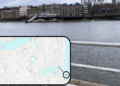
Families are being encouraged to ditch the wheels and walk to school thanks to a collection of colourful ‘walking maps’ specially designed for 27 schools in Southwark.
The maps put the school at the centre, and colour code the surrounding area to show where is within walking and cycling distance.
Designed by the council’s sustainable travel team, they are large, waterproof, and can be displayed anywhere.
Southwark Lib Dems say free school meals scheme should be expanded to secondary pupils
Sarah Parch, headteacher at Galleywall School, Bermondsey, said: “Our Walk to School Month and the use of Southwark’s walking maps have supported children in walking to school, meaning less traffic on the roads and helping provide cleaner and safer streets for our families.”
Galleywall School recently received gold accreditation in the TfL Sustainable Travel: Active, Responsible, Safe (STARS) programme, recognising its success in moving parents to sustainable modes of travel.

It is one of fifteen school to have its nearby pavements widened by Southwark Council, in a bid to make the roads feel safer and more spacious.
The council supports all schools on their journey through STARS accreditation offering walking, cycling and scootering training.
The council says that, to date, it has helped 25 schools close their roads at drop-off and pick-up times.
Exclusive: Headteacher slams regeneration policy as Southwark schools crisis mounts
Relatedarticles

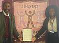
Cllr Catherine Rose, Cabinet Member for Leisure, Parks, Streets and Clean Air, said: “It was a pleasure to meet the staff and students at Galleywall School and talk about the progress they’ve made in reducing traffic around the school, as well as their hopes to further this work in the future.
“The students proudly showed us the school’s packed scooter parking spot and explained how they all walk, cycle and scoot to school. We hope that our new walking maps encourage even more children and adults to make their journey sustainably and safely.”


